When will the first homes be built?
The first homes are expected to be completed at Folsom Ranch (the portion of the site west of Placerville Road) in 2018 and at Russell Ranch (east of Placerville Road to the county line) in 2019. Stay up-to-date by registering on the “Contact” page to receive information when it becomes available.
What is the Folsom Plan Area?
The Folsom Plan Area, also known as South of Highway 50, is the 3,520 acres that was approved to be added to the City of Folsom’s sphere of influence in 2001. It includes all of the land bounded to the north by Highway 50, to the south by White Rock Road, to the west by Prairie City Road and to the east by the county line. The plan area is a comprehensively-planned community based on Smart Growth and Transit Oriented Development principles that includes a mix of residential, commercial, employment and public uses complemented by recreation amenities, including a significant system of parks, open space and interconnected trails.
How was the plan created?
The site was the subject of a visioning process instituted by the City of Folsom that brought together hundreds of Folsom residents at several meetings to address a range of issues including land use, open space, transportation, and financing. Their recommendations resulted in five different development scenarios which were reviewed by the Folsom City Council in 2005. The current plan that was ultimately approved by the city council in 2011 is based on those community meetings. Since then, the details of the plan area that have moved it from a concept to the point that construction will begin, including environmental documents, implementation plans, ordinances and more, have been reviewed at numerous public meetings.
What is Measure W?
Measure W was a ballot measure approved by Folsom voters in 2004 that ensures the plan area will secure an independent water supply, schools, roads and infrastructure, all at no cost to residents north of Highway 50. The measure also called for 30 percent of the land to be maintained as natural open space for the preservation of oak woodlands and sensitive habitat.
Where will the water come from?
Pursuant to changes in state law, in 2010 the City of Folsom developed a water management program to make sure the current delivery system was functioning properly and any saved water obtained through leaky pipe detecting and repair would be used within the city limits.
The city determined that the water system could be optimized, repairing leaks to recapture water that, by law, could not be used for existing residents. However, the law allowed the water to be used for future residents within the city’s plan area, such as the Folsom Plan Area. As a result, the city created a plan whereby the landowners south of Highway 50 funded nearly $8 million in leak repairs while the recaptured water would be used to serve existing Folsom residents. In turn, the $1 million annual surcharge being paid by existing residents of the Parkway, Empire Ranch and Broadstone neighborhoods will be borne by the landowners in the plan area. The water savings these measures generated, plus a modification in the city’s water contract with Aerojet, recaptured 5,600 acre feet of water. That is more than enough to supply the future needs of Folsom Ranch, so rather than relinquish or sell it, the city elected to reallocate the water to the plan area.
How many homes will be built?
The Folsom Plan Area Specific Plan permits the construction of approximately 11,337 residential units across a wide range of home types. Some will be stately homes with stunning views, others will be modeled after Folsom’s most popular neighborhoods to serve a variety of households. The plan area embodies a vibrant and walkable urban core, designed with a mix of housing, retail and employment.
How many schools will be built?
More than 130 acres are set aside for five elementary schools, a middle school and a high school to serve the students at Folsom Ranch. The schools will be located throughout the site to serve the new neighborhoods.
Are parks included in the plan?
Yes. There are more than 138 acres planned for parks, including park sites adjacent to each of the elementary schools. That includes two, large community parks; one in the eastern area that is 26 acres and one in the western section that is more than 50 acres.
What will Folsom Ranch do about traffic?
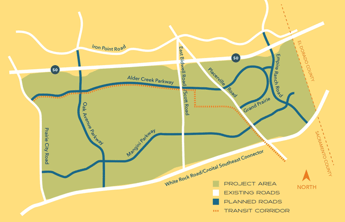
Measure W and good planning principles dictate that the plan area mitigate its impact on traffic. To that end, Folsom Ranch has an elaborate collector road system that is designed to direct traffic away from Highway 50 and other parts of Folsom. For instance, Alder Creek Parkway will run parallel to Highway 50, much like Iron Point Road on the north, and two major arterial roadways will move traffic east and west within the plan area.
A built-in transit corridor that extends the length of the property is designed to reduce dependency on Highway 50 while also reducing greenhouse gas emissions. Landowners in the Folsom Plan Area are funding roadway improvements north of Highway 50 and in Sacramento County as well as their share of the 34-mile Capital Southeast Connector that will link El Dorado County to Highway 99 and Interstate 5 in Elk Grove.
The plan includes new interchanges for Highway 50 at the future extensions of Empire Ranch Road and Oak Avenue Parkway. Empire Ranch Road will be lengthened to pick up White Rock Road. The two interchanges are designed to help relieve congestion at the Scott Road/East Bidwell Street exit.
How much land will be preserved as open space?
Measure W called for 30 percent of the land to be dedicated as a natural resource area. That is more than 1,000 acres, including more than 500 acres of contiguous oak woodlands, meandering natural creeks and preservation of sites with historic artifacts, sensitive habitat and wildlife that will be available for public enjoyment via more than 30 miles of hiking and biking trails.
Will there be business campuses and the chance for more jobs?
There are 320 acres dedicated to commercial/office use, including the possibility of campuses for the regional, national or international headquarters of large companies. Nearly 8,000 new jobs are expected.
What construction will be done first?
An 18-month schedule of infrastructure and road improvements will include water, sewer, streets and utilities. The Sacramento Municipal Utility District will build a substation near Placerville Road to serve the area with electrical power.
How will construction at the site affect me?
Construction activities will require temporary closures and detours of Placerville Road and Scott Road. See the traffic management plan here. Traffic safety and detour signs will be posted. Alder Creek Parkway, an east-west connector, will be built between those roads, eventually running parallel to Highway 50, similar to Iron Point Road to the north. Site preparation for a new sewer line west of Scott Road may be visible from Highway 50 and White Rock Road, but will not impact traffic.
Where can I get more information?
Register on the website to receive updates. You can see the Folsom Plan Area Specific Plan and other documents on the City of Folsom website at http://www.folsom.ca.us/FolsomPlanArea