Over a decade ago, Folsom voters overwhelmingly passed Measure W, which called for the City of Folsom to take control of a 3,500 acre area bounded by Highway 50, White Rock Road, Prairie City Road and the El Dorado County line.
The reason for passage was simple: to ensure that future development of this area would protect the long-term quality of life of the Folsom community, rather than let it get into the hands of some other entity that might develop it irresponsibly and without accountability to Folsom residents.
Today, after dozens of public hearings and the participation of hundreds of Folsom residents, a plan for development has been created, vetted and approved by the Folsom City Council – and construction work has begun.
Welcome to Folsom Ranch
It’s a rare community that can be planned from the ground up – with the opportunity to design a nearly perfect place to live and work. Folsom Ranch is such a locale.
To be sure, the ground in this case is exceptional: 2,650 acres across the heart of Folsom’s annexation area, terrain that traverses grasslands, gentle hills, creeks, wetlands and thick stands of heritage oaks. The full annexation area is 3,520 acres, and Folsom Ranch is its heart.
When we flip the switch to turn on the lights, we rarely think about what it took to get the electricity there. A new SMUD substation in the Folsom Plan Area will distribute power to the new homes and businesses coming to the site. Here is a time-lapse video showing a crane moving a 95,000 pound transformer into the substation. The transformer was brought to the site on a 58-wheel big rig. SMUD substation technicians worked with choreographed precision and an emphasis on safety as they placed the transformer on its foundation.
Highlights include more than 1,000 acres permanently protected as open space, including precious oak woodlands, 138 acres of community parks open to the public, an independent water supply at no cost to Folsom residents and that doesn’t diminish Folsom’s current water supplies, transit improvements from a landowner fee program that will mitigate traffic impacts from the plan area, beautiful homes, a vibrant town center, high quality jobs, and new schools that will be funded entirely by the new residents of the area, not current Folsom taxpayers.
Background of the plan
The final plan, adopted in 2011, has been widely praised for preserving natural assets within a dynamic, inclusive community. Everyone who helped devise the plan – landowners, city and county officials, hundreds of Folsom residents – all supported the goal of creating a livable environment that would enhance the city and reinforce Folsom’s “pride of place.”
The concept of annexing the land south of Highway 50 was proposed in 1992. From 1996 to 2000, the Folsom City Council and Sacramento County Board of Supervisors negotiated a memorandum of understanding on how the land should be developed. Those guidelines became the basis of Measure W, the ballot measure passed by Folsom voters in 2004.
The decades-long process of planning the project encompassed smart growth principles, visioning charrettes, the ballot measure that stipulates many aspects of design, specific plan and EIR/EIS reviews, and many workshops and public hearings.
“This is the people’s plan,” said Steve Miklos, mayor of Folsom. “This is the plan that was requested by the community.”
Supported by the community
At the Folsom City Council hearing to adopt the final plan in June 2011, 20 speakers, from stakeholders to residents, lauded the project.
One of the strongest endorsements came from Mike McKeever, chief executive officer of the Sacramento Area Council of Governments, who cited the open space and parklands, multiple transportation options, mix of land uses, attention to detail and adherence to SACOG Blueprint principles for more livable communities in singling out the project as an example for other development in the region to follow.
“Your plan is remarkably consistent with … what we have been encouraging our cities to do in following the Blueprint principles,” he said. “All of that is just a home run as far as we’re concerned.”
Resident Dennis Rogers characterized Folsom as more of a community than a city. “This plan not only maintains that but actually builds on it,” he said.
The late Madeleine Moseley, a 75-year resident of the area who long served as a city sentinel, represented the sentiment of many current residents: “This project is great. We really need it, especially the White Rock Road improvements. People want to live in Folsom because we have everything here.”
Enhancing our quality of life
Folsom Ranch is aimed at protecting and enhancing our quality of life. Here are some of the highlights, with detailed information on linked pages:
30% Open Space: This is the area’s true prize. A full 30 percent of the site will be left in its natural state. This allocation does not include the ample acreage also set aside for parks.
Water Independence: This once-sticky issue has been resolved with no costs to existing Folsom residents nor any reduction in their water supply. Indeed, it will result in a reduction in the rates paid by many residents of the east area of Folsom. The landowners have footed the entire bill to bring water to the south area.
Transportation Improvements: Planned projects, including a limited-access road alongside Highway 50 and an innovative transit corridor, will keep the area’s traffic from overwhelming nearby communities and give residents workable and walkable options for ditching their cars.
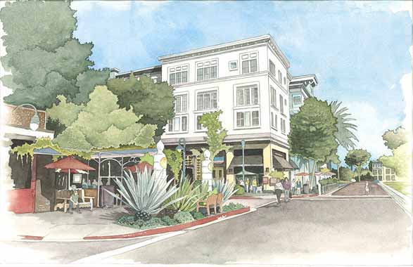
Vibrant Town Center: Right in the middle of the plan area, and part of Folsom Ranch, will be a vibrant “village core” with all the assets that make small towns so appealing: a civic center, aquatic center, library, high-density housing, community recreation facilities, easy walkability, multiple transportation options and more. Residents of the town center may never need to use their cars, said Mayor Steve Miklos. The suburban-style neighborhoods that fan out from the town center will have direct transit access to this core area.
Public Parks: The area will feature two large community parks and smaller parks accessible to every neighborhood, at least 138 acres total.
Hiking and Biking Trails: Folsom is already respected for its biking and hiking trails, and this area will add to them in both quantity and quality. They’re planned to be practical as well as recreational.
Quality Housing: Over the next 25-30 years about 11,000 homes will be built in the entire plan area. Some will be stately homes with stunning views, others will be modeled after Folsom’s most popular neighborhoods to serve every family situation and income level.
Quality Jobs: Up to 8,000 jobs are expected here at buildout with a balance of employment opportunities that includes high-paying jobs at corporate campuses.
Schools: By the time the project is complete, Folsom will have a third public high school and middle school and five more elementary schools. All schools will be fully funded by state funds, general obligation bonds and developer fees at no cost to existing Folsom residents.
History: Folsom is one of California’s most historic and history-minded towns, and evidence of Native American habitat and gold mining activity in the area is being preserved and curated.
Folsom Planning Director David Storer summed it up perfectly at the 2011 public hearing: “This property is going to be drop-dead gorgeous,” he said.